Hiking in the Alps
Tracks
| From Bern to Emmental (Green Switzerland) | GPX | 28 km | 11/10 |
| Oeschinensee (Blue Switzerland) | GPX | 13 km | 10/10 |
| Bussalp - Bachalpsee - Grindelwald (Yellow Switzerland) | GPX | 16 km | 9/17 |
| Through the Wimbachgries (Gray Germany) | GPX | 23 km | 13/13 |
| From Berchtesgaden to Kessel (Green Germany) | GPX | 22 km | 21/20 |
| A day at the Königssee (Blue Germany) | GPX | 13 km | 7/7 |
Descriptions
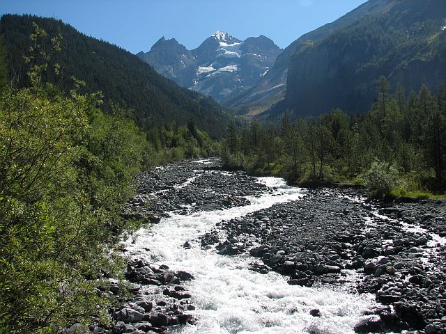
From Bern to Emmental: Green Switzerland
This trail sets out at the main station of Suisse's 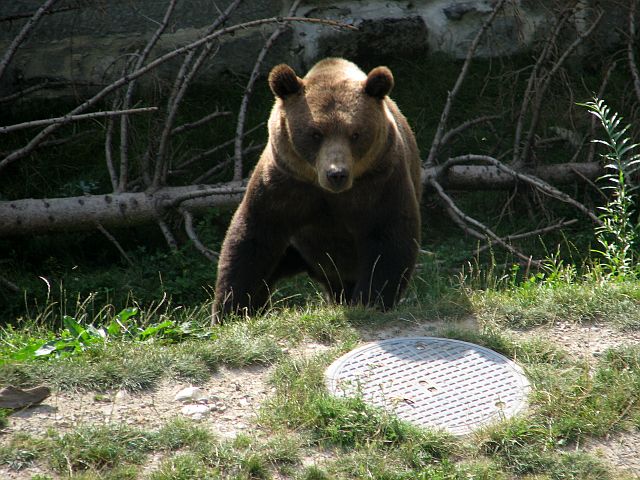 capital (no debate here) and leads out over green meadows along sights of the Berner Oberland mountains to the rural Emmental the eponymous valley of one of the most famous cheeses. By chance the old city center lies to the right side (into the right direction) which is why the tour begins with an urban sight seeing tour. Ah, well, urban... there are suddenly these bears... luckily in a kennel and also luck for them in a rather new kennel, as their old one for sure did not allow a good life for a bear. One has the impression to leave the city two or three times, but it is just forest which is enclosed in the city. Passing between a wooden hill and high-rise residential houses the city gradually bids farewell and is entirely left behind once for the first time one has to rise an elevation worth mentioning. Nevertheless, it is barely more than 100 m and the landscape gives
 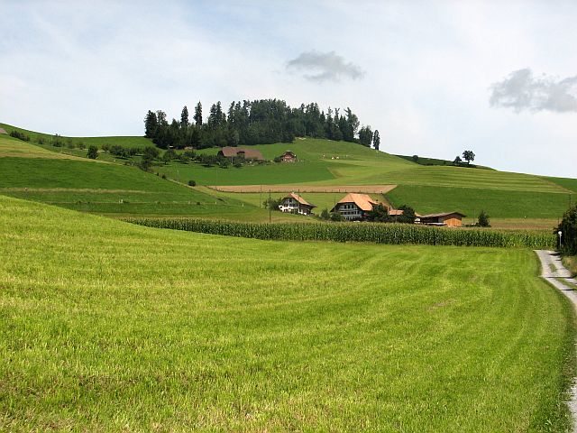 the impression of a flat agriculturally dominated terrain.Acres alternate with forest and from time to time there are large farm houses of the local type (of course). Shortly behind Dentenberg we have to return down the risen meters steeply and when doing so we see on the opposite site of the valley before us the major part of the remainder of the track – at least that's what it seems like. At the floor of the valley we pass through Boll an immediately thereafter start to walk upwards for about six km. While the incline stays about constant all the time, the landscape changes slowly. It seems to become ever more green. To our great surprise at Littewil – about 1 km ahead of the passageway to Emmental – one has a view back to Bern and a major share of the day's work so far. This is the time and place for the major rest of the day. When finally today's peak – with less than 1000 m an unremarkable value for a trail in Switzerland – is reached the mountains of the Berner Oberland present themselves as a reward. From her
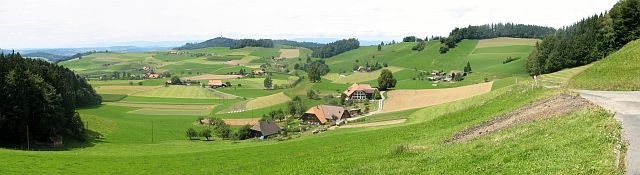 e to the destination Goldbach it is 9 km or two and a half hour, almost all downwards. Along the way we note that the village of Schafhausen (sheeps' home) is dominated by cats, while the sheep hide in an adjacent forest.
Clear view: 5/5
Nature: 5/5
Culture: 3/5
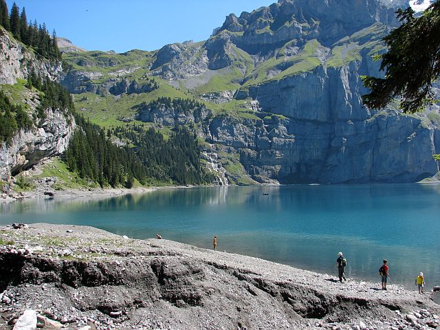
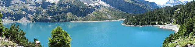
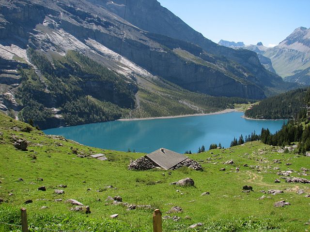
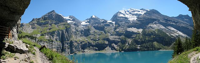
Oeschinensee: Blue Switzerland
Go to the parking place of the Gondelbahn (cableway) 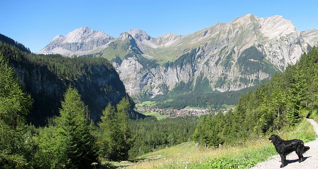 Kandersteg Oeschinen in Kandersteg and follow the stream of people up the mountain along the hill. It will take you about one and a half hour to reach the Oeschinen lake. You can walk further along the shore of the lake and later above the lake as far as you want. Beyond the two restaurants at the Oeschinensee there are the Underbergli or the Oberbergli huts are good possibilities for a rest and turning point. Enough words for this tour, let pictures speak.
Clear view: 5/5
Nature: 5/5
Culture: 1/5
Bussalp - Bachalpsee - Grindelwald: Yellow Switzerland
This is a tour of the most marvelous clear views 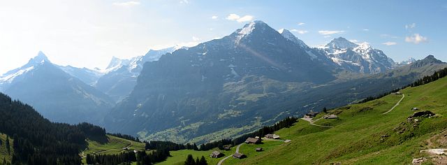 one can probably think of. In principle it would be possible to do it as a round trip starting and ending in Grindelwald. However, we choose to cheat and take the bus from Grindelwald (1040 m above sea) to the Bussalp (1800 m above sea). For everyone coming from a low-wage country (aka non-Switzerland) this is not a cheap cheat, but this is forgotten already in the bus when the panorama of Eiger, Mönch, and Jungfrau becomes clearer, and even more so when one finally can step out of the bus. The steepest (actually the only) incline of the track follows right on the first four kilometers on which we rise by 600 meters to the Hireleni pass. This means we stay right to the higher summits of Reeti, Simmelihorn, Esel, and Faulhorn, as well es the Reetihitta pass. On the way along Bussalpbach, even before reaching das Feld (a rather flat area which is used for
 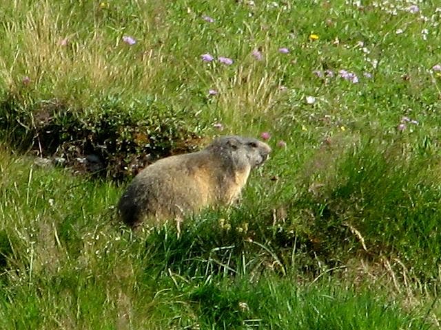 agriculture) a marmot greets us not without taking its bows and disappearing again before we come too close. These four kilometers should be doable for everyone who is not scared of having to walk upwards that long (which actually is not so much, as from Gernsbach to Teufelsmühle in Black forest there are 50% more meters of elevation to be done) and who has decent shoes. All along these four kilometers one has a slightly changing perspective of Eiger, Mönch, and Jungfrau. Shortly before the pass we take a first rest. Here, around the pass, the mountains are all assembled in one single view: Eiger, Mönch, Jungfrau, Schreckhorn, Lauteraarhorn, and Finsteraarhorn. The pass itself does not only turn the vertical direction of the track, but also implies a sharp turn to the left (north-west). From now on we see the Bachalpsee before and below us. Mind your steps and look to the path and not only to the lakes. With good weather at that day and the First cable car nearby the lakes were crowded. We took lunch at the lakes,
 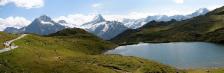 enjoying a different but equally impressive mountain panorama and towards and through the Bachläger which was crowded not only with tourists but also with cows. The 1100 m we have to lose from Hireleni to Grindelwald are distributed almost equally along these 11 km interrupted only by very short steeper passages. Almost equally gradually the ambient changes from high-mountainous to settlement; the Waldspitz hut where we rested for the last time, is already served by a bus and – as the name tells – the trees reach up to that elevation, which gives the spot already a low mountain range ambiente, if it were not for Eiger being right on the other side of the valley.
Clear view: 6/5
Nature: 5/5
Culture: 1/5
Through the Wimbachgries: Gray Germany
The Wimbachgries is the valley between the 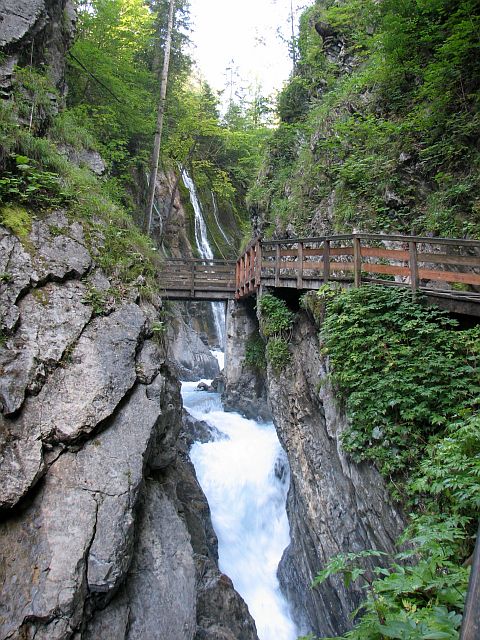 mountains Watzmann, Hochkalter, Hundstod, Seehorn, and Hochheisspitze near Berchtesgade or Salzburg, respecively. As all of Germany's Alps the mountains belong to the Northern Limestone Alps, implying that nearly all covering stones are rather permeable to water. At the entry of the Wimbach valley it appears however, that there are some less permeable stones (cherts?) at the foot of the mountains. As a consequence in the Wimbachklamm (“Klamm” = small canyon) which is the entry to the whole valley water appears to be pressing out of the stones. Above it seeps into the limestone and thus disappears from the surface. Wherever this happens somewhere else water has to come to the surface when it is blocked by “waterproof” rocks. In the case of the Wimbachklamm this happens in a highly aesthetic way. The Wimbachklamm is not very extended and above it one follows a blue-turqois creek upward, which flows in a rocky bed (don't know why here the water is at the surface, the rocks look like limestone, but maybe there is just too much water here). The rocky nature of the valley (think of “Gries” as a short name for “Geröll/Kies” = bowlder/shingle) becomes more and more apparent, but here it is still covered with a dense forest through which we are walking for something like an hour. The valley here is still rather narrow – although not a canyon anymore. In fact there once was no valley, but simply rocks which blocked the water from behind such that what today is the upper valley then was covered by a sea. Above an artificial terrace the creek's bed is empty. Somehow the water – at least in summer time – must flow sub-surface. About at this point also the valley is narrowest in an
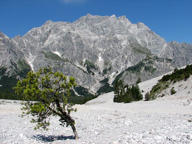 altitude of 900 to 1200 meters (at lower altitudes it is of course in the Klamm). This bottleneck later makes for a nice frames in photographs. Short time later and in total after about one hour we reach the Wimbachschloss (Wimbach castle). It is not exactly as impressive as Neuschwanstein, but in case you've missed the breakfast here would be a chance to get some. In this area the different layers of the former sea ground can very well be seen in the immediately surrounding mountains. According to the geologists we are now moving further and higher from limestone to Dolostone. It is not washed out as easily as limestone, but it breaks quicker. Consequently the valley becomes wider, the stone-covered gray areas become larger, but still there are trees. Without much effort one reaches the Wimbachgrieshütte in about one more hour. This hut is another – I would say even better – place for a rest, but it is also a crossroads: from here a trek runs via Trischübel to the Königssee or the Kärlingerhaus (near the Funtensee, Germany's coldest spot) or the Ingolstädter Haus and thus also the Steinerne Meer (“stone sea”). After a rest, we had planned however, not to walk one of these eastbound ways, but in western direction, once more over the Gries to the Loferer Seilergraben. Here, step by step the landscape becomes more and more bizarre, I would say
 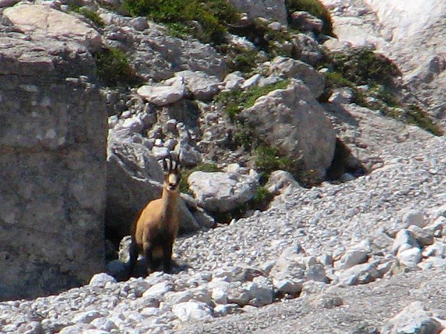 “Martian” if it wasn't nonsense offering an experience as comparison no-one ever has made. While we were there no-one else chose to walk this way, which contributed to the intensity of the experience. When we were actually at the Loferer Seilergraben, we felt to be “inside” it (and in fact some geologists say that in former times there was an upfold spanning from Watzmann to Hochkalter which collapsed and eventually created the Wimbachtal, where before there was a summit far higher than Watzmann and Hochkalter are today). All rocks loom steep and high. Bizarre rock fingers point to the sky. We saw an Alpine Chamois which lurked long – as if it couldn't belief that someone moving so edgy would come here – before it finally fled. Almost permanently in the silence one could hear sand and small pebbles trickling down the mountains, something which shifted the atmosphere from “impressive” to “threatening”. Following our visit there I found on the web someone speculating how much longer it would take before the Große Palfenhorn would collapse. Honestly, it would be exaggerated to say that in the Loferer Seilergraben death lurks behind each stone, but it surely is not in the top ten of the world's spots to be to see the next day. You do not necessarily need good luck to make it there and back, but a bad luck
 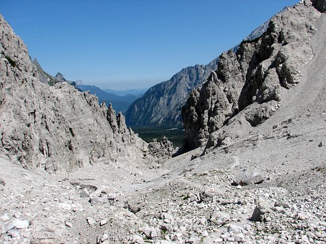 day might be your last. I'm very critical of web reports calling a skiing tour including the Loferer Seilergraben an “easy” one. As we had progressed only slowly since we had left the Wimbachgrieshütte, we were not sure, if we would make our variant A – passing to Austria over Hochwies and Seekopf in time (for the last bus at Kallbrunnalm) and if the meters immediately ahead of us were actually more or less dangerous than they appeared, we chose variant B: return back the same way we came not without a second break at the Wimbachgrieshütte. There we witnessed a joined exercise of rescue forces and German federal police with two helicopters, which proved that the Gries not only consists of rocks, but also lots of dust. Although it was the Loferer Seilergraben who forced us to turn around, we were happy to have been particularly there and consider this variant B to be a great tour.
Clear view: 4/5
Nature: 5/5
Culture: 1/5
From Berchtesgaden to Kessel: Green Germany
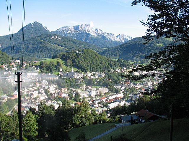 difficult to choose those few pictures to be shown here next to the text. This is not only because of the many great pictures of the Königssee, but even more because of the many different impressions the trek offers. We started early in the morning in Berchtesgaden at the parking place of the Obersalzbergbahn. Of course one could shortcut the first 500 meter of elevation using the cableway, but we chose to walk and were rewarded with marvelous views of Berchtesgaden as we slowly passed the level of this morning's mist. As soon as Berchtesgaden got out of view we had the first full view of Watzmann and Hochkalter and the clouds covering the Königssee. To our surprise after the Sappenlehen the path turned downward again and at the Stockerpoint-Lehen appeared to dead-end. However, it was possible to pass the farmhouse with its still tired-looking sheep. Behind it the path first lead along a creek which came
 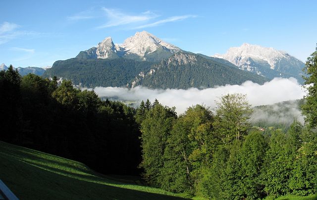 steeply down the mountain over a sequence of small waterfalls. Here it was shadowy, therefore quite cold and definitely lonely – a sharp contrast to some later passages; I love it when trails include such contrasts. When the path turned away again from the creek it got steeper and the steeper it got the worse the ground became. When the grade was moderate again we walked single file on a barely visible path. If from he map we hadn't known that the Scharitzkehl road is not far above us and that we were walking parallel to it (for quite some time) we might have turned around. Finally we reached a wider path again which – passing some artistic goats – relatively soon brought us to Vorderbrand and thus a coffee. While the first five km of the day took us two hours these last 1.5 km just made up for 25 min. Now today's main “job” was visible, the Jenner and while so far the day was not really difficult, in
 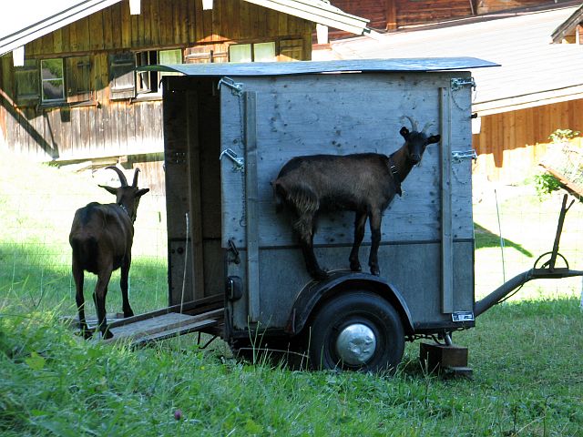 combination with what was now before our eyes we realized the extent of what we had planned for the day. Still we were not despaired enough to choose for Jenner's cableway, but to save some time chose to walk the direct, steeper way toward the Mitterkaseralm. Along this ascend one has a great view down on Schönau, but not yet the Königssee. The sun was stronger now. In combination with us climbing 100 m higher each 12 minutes the day felt to be a very hot one and I was actively trying to walk in the shadows. The Mitterkaser-Alm (a hut) is nicely located on a meadow “behind” (“behind”, if the Königssee is in front and Austria is behind) Jenner's summit. On the way from Mitterkaser-Alm to the Jenner's summit we saw on the oppositely located flank three cows rushing downward to the Alm as if there was last call. I've never before seen cows to behave so hectically. The way between the top station of Jenner's cableway and Mitterkaser-Alm is well populated on a day like this. Somewhere
 along the way the Königssee comes into view for the first time. The top station itself, however, was really crowded and way from there to the summit was near capacity – honestly: normally it would be a five minutes walk, but it took me almost twice as long. Considering that with 1874 m the Jenner is by far not among the highest mountains of the region one has a great 360° view from its top, including the Königssee and particularly the Hirschau with St. Bartholomä. This together with the convenient cableway explains the hustle and bustle up there. At the lunch on the terrace of the top station we were hauntingly stared at by some crows (Alpine Chough, I guess, those with the yellow bills), but only until at our
 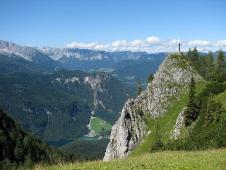 neighboring table someone arrived with a plate full of French Fries. Obviously the ravens have a clear priority list of favorite foods and insects – which are mentioned as their food in the textbooks – apparently are not their prime choice. Our neighbor actually left with some fries left over, but not for long. Interestingly as long as humans were near the food they did not come all too close, however, they also did not let themselves be driven back by some guy waving his arms toward them, but tried heavily to maintain a good starting position for the time when some human left his place. Jenner's cableway tempts to call it a day and quickly go down again, but now that we had made it to the planned roof of today's tour there was no reason not to walk down. Along a zig-zag way which ends at the Königsberg-Alm we lost the first elevation meters very quickly. Short time later we reached the Königsbachalm and as this is operated as well as a small restaurant there
 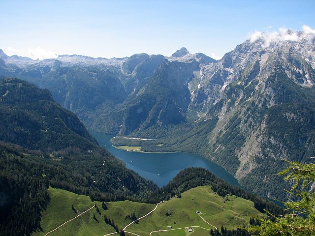 are really much more opportunities to rest and eat in his region than one can realize, at least if the day should keep its character as a hiking day. To our surprise immediately following the Königsbachalm the path led uphill again. Just for 100 m, but these summing up to those before at that day felt arduous. Then when the way turned downward ultimately we entered a forest which we stayed in almost until we reached the shore of the lake. Some more views of the lake would have been nice, but that's how it is. The last part of the trek was a zig-zagging, but nevertheless still was quite steep and for me appeared to be the most arduous part of the day. When we reached Kessel it was still early enough that we could enjoy the beach for an hour. Kessel is a small – better: tiny – peninsula in the Königssee. Just by chance the mountain flank above it is not so steep that there cannot be a path which we used today and which in former times actually was used to bring cattle to the alps. There were a few people there having a
 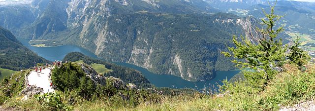 day at the beach as the Berchtesgaden region has a plethora of hiking opportunities, but not really beaches. Kessel is one of the better spots for this. Apart from using the way we came to come or leave (which implies a minimum of 600 meters of elevation) the only other access is via the lake. Kessel is a request stop for the Königssee ships. One has to pull out a red board and a few minutes later one of the ships coming from St. Bartholomä will stop by and take the hikers on board, provided there is sufficient free space on board which is not guaranteed on such a day. There is another board to call ships toward St. Bartholomä, but that is very rarely used. While we were there at around 4 PM there actually came some hikers who just started their ascend at that time. In our thoughts we wished them good luck and were happy that the remainder of our day could be spent at very moderate levels of activity. With 22 km this trek is not really long, but a sum of 2,000 uphill meters has its effect.
Nature: 5/5
Culture: 1/5
A Day at the Königssee: Blue Germany
This is more a vacation day with a hiking 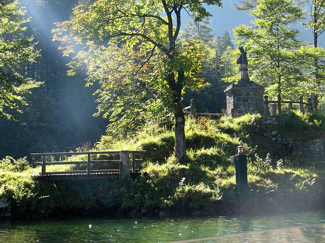 component than an actual hiking tour. And it is a very typical vacation day as many tourists in the Berchtesgaden Alps do it. It is a bit of a paradox: it is common, because it is special. The shores of the Königssee at most parts are so steep that they cannot be accessed. It is therefore often said that the lake gives the impression of a Norwegian fjord. A ship bus service connects the larger accessible points or those from where paths lead on. The “main harbor” is the northernmost point “Seelande”. Unless one does a somewhat extended hiking tour (see the tour “From Berchtesgaden to Kessel”) one typically boards a ship there for the first time of a day. Principally all destinations can be visited in arbitrary order. We alight first at the peninsula Hirschau with the famous chapel Sankt Bartholomä. On the way there the ship’s First Officer explains all the famous
 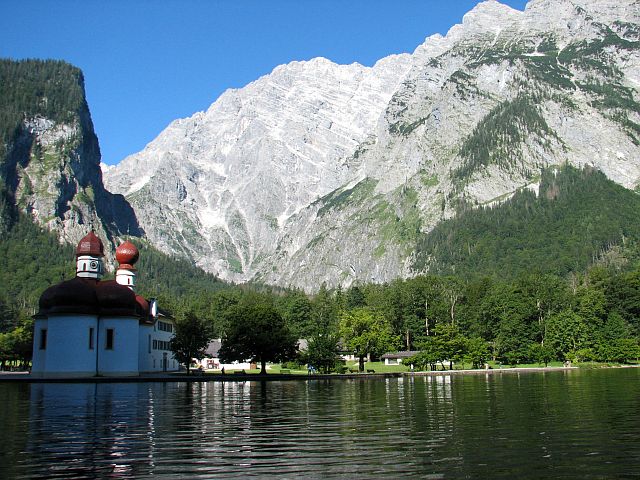 facts about the lake (it is one of the cleanest in Germany, all ships run with electro motors, the lake is up to 200 m deep, that in sixteensomething a boat with pilgrims capsized where there is a cross at the rock above the water, nothing at the lake may be changed, nothing may be constructed due to its nature protection status, etc.) and plays the trumpet to demonstrate the famous Königssee echo (and to offer the passengers a chance to get rid of even more Euros than the ticket anyway costs). The Hirschau was formed by the Eisbach (Ice Creek) which flows down from the Watzmann. At some time in the future the Eisbach will have extended the Hirschau so much that it divides the lake into two parts. We follow a path away from the lake and toward the Watzmann. First flat through a dense forest, then – after we have passed another chapel (the Hirschau basically holds three houses: two chapels and a restaurant) – increasingly steep through a dense
 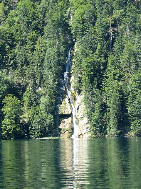 forest, but there’s no difficulty linked with the path. Our destination is the so called Ice Chapel. This is not a building, but a snow field which never melts entirely in summer, but is carved out at its bottom by the waters of the Eisbach. One could also have called it Ice House or Ice Dome, but at Hirschau there may only be chapels and restaurants, and Ice Restaurants would have made even more people walk inside. However, walking inside or on top of an ice chapel is highly dangerous as it may collapse at any moment, actually at other spots on the mountains around the lake one can see other chapels which have collapsed. Before we reach the chapel the path gradually becomes more demanding. Many people we saw definitely chose the wrong shoes for the day as they obviously conjectured that at a spot as heavily frequented by tourists as the Königssee all paths must be paved (which will never happen, as nothing here may be changed, see above). The last few meters in front of the chapel lead over really rocky grounds and at the gate the air has an estimated temperature of 5°C and flows steamy down the valley hovering over the Eisbach.
 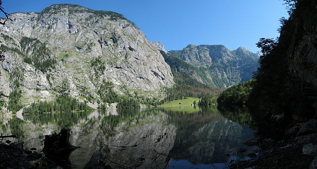 We go back to where the easy (non-Alpine) path ends and rest a bit at the lake. It is possible to continue here toward the Watzmann and reach for example to the Wimbachgrieshütte (see the tour “Through the Wimbachgries”). So we return back to Sankt Bartholomä, take a look inside the chapel and test the espresso of the restaurant (quite fine and all in all astonishingly reasonable prices considering the fact that the next competitor is a ship tour or a mountain passage away). Then we continue with the next ship to the stop Saletalm. From there the usual walk leads to the Obersee and perhaps to its opposite site. The Obersee is famous for that it is very calm and therefore the mountains around it are almost perfectly reflected on its surface. The highest waterfall of Germany, the Röthbachfall,
 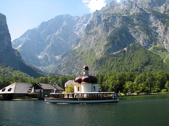 falls into the Obersee, at least in spring. When we were there it was almost dry. After having shot about 100 more photos we go back to Salet. From this ship stop also an number of “slightly” more arduous trails set out as the one to Funtensee (Germany’s coldest spot) and the Kärlingerhaus, but beware for this you do not only have to make more km and more altitude, but the trail is also marked as difficulty category black. As the day is not yet over, we interrupt our ship tour back at Kessel and use or abuse this spot for an hour or so as beach. The Berchtesgaden region is rich on hiking opportunities, but there is no lake which really qualifies for a day at the beach. Therefore we are not the only ones declaring this tiny and rocky peninsula as a beach, but it is used by a number of other people as such at this day. Before the sun sets we set the flag to call a ship to take us back to Seelande.
Clear view: 2/5
Nature: 5/5
Culture: 4/5