Hiking Down the Neckar Valley
The following four tracks can be attached 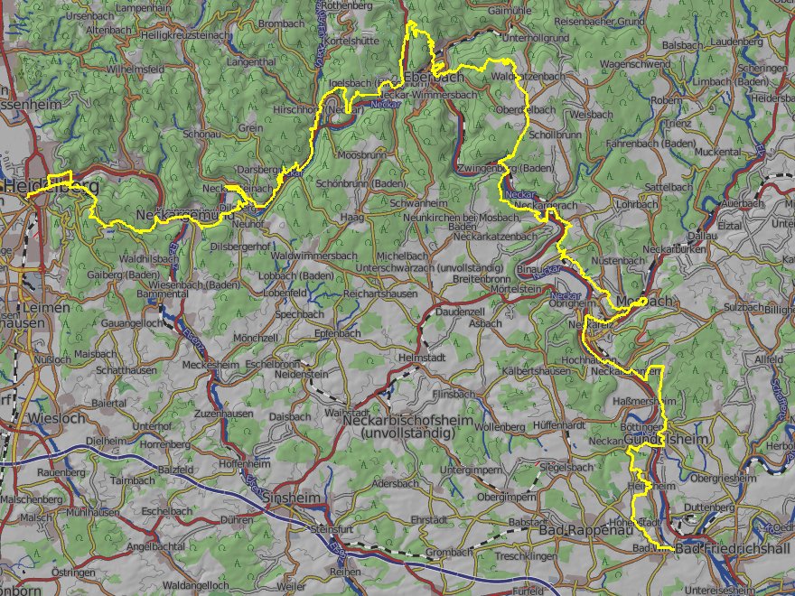 one to the other to walk from Bad Wimpfen to Heidelberg). The missing part "from Eberbach to Hirschhorn" is not that long. "Mosbach to Binau" already fills a gap. So, if you plan to do all the way gapless, you need to think about a better distribution of the route on the days, as the legs here have unequal distances and doing just three legs might be too few. Following newspaper reports from early 2010 the regional authorities plan to create an official trail in the region called "Neckarsteig". The tracks on this page here might have some parts in common with the upcoming Neckarsteig (which sometime in 2011 is announced to be presented here), however, these tracks are not the Neckarsteig. The overview map at the right top of this paragraph is an excerpt from openstreetmap.org, rendered by wanderreitkarte.de, it is licenced under Creative Commons. The track is not the Neckarsteig. It is as well not identical with the GPX tracks downloadable above. I have modified it to have it as one continuous track and made some improvements that I got aware of only later. Furthermore I've added the parts from Eberbach to Hirschhorn and Neckagemünd to Heidelberg, which I have not yet been walking along (take especially care with these). Download the full track. The name of the official Neckarsteig that will soon be introduced suggests to walk from Heidelberg to Bad Wimpfen. Yet the track(s) as I have them I suggest to walk the other direction as then you will walk upwards the two canyons (Margarethenschlucht and Wolfschlucht), which is safer and I think also offers the better views.
This part of Germany has become world-renowned as it 1) includes the Castle Hornberg, the spot at which Goethe's "Götz von Berlichingen" is located in large parts and 2) as here Mark Twain did his rafting trip from Heilbronn to Heidelberg and described much of the region of the following tracks quite extensively. So, let's start with one more quote from this work: "Germany, in the summer, is the perfection of the beautiful, but nobody has understood, and realized, and enjoyed the utmost possibilities of this soft and peaceful beauty unless he has voyaged down the Neckar on a raft." Twain then compares rafting to any other mode of traffic and complains about "perspiring pedestrianism". Well, today, he might think differently, as evading all the large ships with a raft would be more than arduous. So there's no chance left today than to walk. Don't go by bike, as by bike, just as by raft and of course by car or train, you would miss the best pieces, especially on the part between Binau and Eberbach.
Tracks
| From Bad Wimpfen to Mosbach | GPX | 28 km | 5/5 |
| From Mosbach to Binau | GPX | 8 km | 3/2 |
| From Binau to Eberbach | GPX | 31 km | 13/13 |
| From Hirschhorn to Neckargemünd | GPX | 24 km | 11/11 |
| From Neckargemünd to Heidelberg | GPX | 15 km | 8/8 |
| From Esslingen to Bad Cannstatt | GPX | 20 km | 5/5 |
Descriptions
From Bad Wimpfen to Mosbach
Bad Wimpfen lies very picturesquely on a 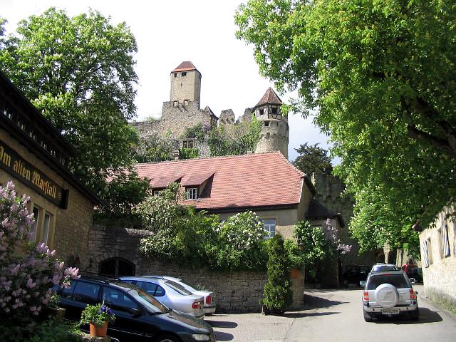 hillside above the river, you'll see this when you leave the train, as the station is down by he river. Looking around the town you'll find it as picturesque from the inside as from the outside. Having left Bad Wimpfen, the trail leads more or less straight-on northbound toward Castle Guttenberg. Maybe you'll see various birds-of-prey, when approaching it, as Castle Guttenberg is the home of Germany's bird-of-prey center. The castle itself is in very good shape, take a look around. Then we need to go downward and cross the river at Gundelsheim. After Gundelsheim we're approaching and ascending to "Castle Hornberg". "Below Hassmersheim we passed Hornberg, Goetz von Berlichingen's old castle. It stands on a bold elevation two hundred feet above the surface of the river; it has high vine-clad walls enclosing trees, and a peaked tower about seventy-five feet high. The steep hillside, from the castle clear down to the water's edge, is terraced, and clothed thick with grape vines. This is like farming a mansard roof. All the steeps along that part of the river which furnish the proper exposure, are given up to the grape." writes Mark Twain and that's how it still is. After Hornberg we have to descend again into the valley and walk - most of the time very close to the river - toward the creek mouth of the Elz in Neckarelz. There the route turns east to follow the Elz upstream to Mosbach.
Clear view: 4/5
Nature: 3/5
Culture: 5/5
From Mosbach to Binau
Follow the gpx track of this side to avo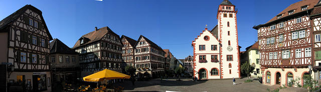 id the traffic-busy valley area in this region. Along the track you will have more than once a good view over the valley. If you haven't done until now, take a look around Mosbach's Old City, before leaving. Take your GPS device with you, as it is hard to find the way on this short track. After a "Bismarckturm" ("Bismarck tower") you will pass the upper end of Diedesheim and then enter the hillside of the "Schreckberg" ("Fear Mountain"), which has already revealed a number of saurian footprints cast in stone. At the end of the Schreckberg, you have to descend steeply into the "Tännichklinge", a small and rather wide canyon that marks the transgression from shell-lime-covered hills to red sandstone-covered-hills. Beyond that point following the right path is particularly difficult, take care.
Clear view: 4/5
Nature: 2/5
Culture: 3/5
From Binau to Eberbach
Maybe this is the most interesting of all trails on this 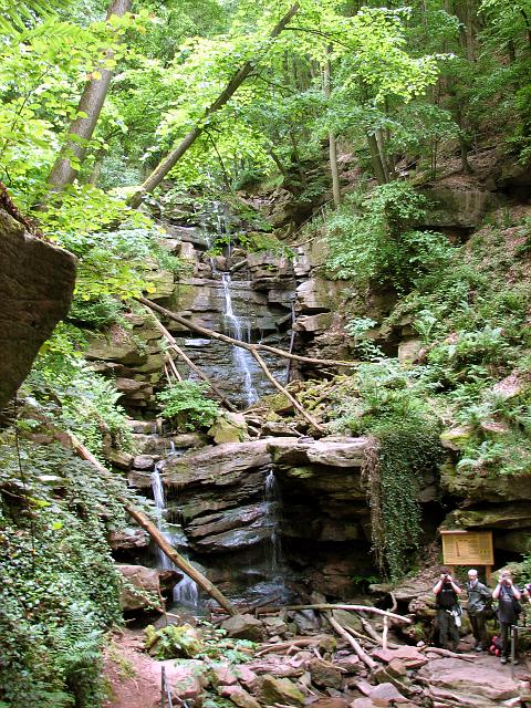 page. Part of the reason surely is that along 30 km there's lots of space for POIs. Starting in Binau the first thing you can see from the "Binauer Höhe" is the nuclear power station of Obrigheim (the oldest one in Germany and the first to go offline). It's a contrast compared to what is waiting on the rest of the track. After the "Binauer Höhe" one has to descend down the "Mordklinge" ("Murder canyon") toward the river again, but always keep the railway tracks between the river and yourself. After a short while you are at the base opening of the "Margarethenschlucht" ("Margarete's Gorge"). The Margarethenschlucht is among the most impressive gorges that follow from here northbound. South of Binau there are no gorges as there the hills are made of with shell limestone, in which incisions into the hills are
  generally wider and softer. Take time when ascending Margarete's Gorge. At the upper opening of the gorge turn left toward the "Gickelfels" with its view over the valley. In Neckargerach the route leads over the river to ascend the "Minneburg" ("Castle of Courtly Love"), a ruin, really ruined but for that reason especially romantic. A famous myth is linked with the ruin. After the ruin you can either stick to the track or walk ever more down for a more adventurous variant. There's a barely recognizable path leading only a few meters, sometimes just centimeters next to the river, to the Neckar ferry of Zwingenberg. Take care for snakes and ticks, if you choose that variant. East otoZwingenberg the second gorge of today, the "Wolfschlucht" ("Wolf's Gorge") starts (or ends) right next to Zwingenberg Castle. It is said that the composer Weber was inspired
 by this gorge for his opera "Der Freischütz". By walking through the gorge we leave the Neckar valley and climb almost 500 m in altitude on top of the "Katzenbuckel" which is the highest hill of the Odenwald. There's a freely accessible tower on top. From here the state of Hesse, which lies north and which from here you can look deep into, appears to be a gloomy forest. Almost exactly to the east you might be able to recognize the radio masts of Donebach, which are the second highest constructions of Germany (following the Fernsehturm
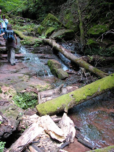 Berlin). The Katzenbuckel - different to the surrounding red sandstone - consists of older bedrock and is an extinct volcano. When walking down from the Katzenbuckel and more or less straight-on to Eberbach take care for an insignificant-seeming pile of stones at the roadside. It could be the remains of the "Emichsburg" ("Emich's Castle"), which was built by a half-brother of Queen Victoria. Immediately above Eberbach there is Eberbach Castle, a ruin relatively large ruin. Having arrived in Eberbach you can enjoy a "Viktoriatorte" ("Victoria Cake") in one of the cafes, if you did not linger too much and it is already too late in the evening. The parents of Queen Victoria lived in Eberbach for some time. It is even said that Victoria was born on a ship on the banks of the Neckar at Eberbach, as her father did not have enough money to leave Eberbach in time for Victoria to be born in Kensington (which later was written in the chronicles, be it true or not). What is true is that still there are households in Eberbach which
  keep some piece of the Queen's parents' household, which they had to sell to get the money for the journey to England. There may not be enough time to go there, but Eberbach is also the home of Germany's tallest tree.
Clear view: 5/5
Nature: 5/5
Culture: 5/5
From Hirschhorn to Neckargemünd
Hirschhorn is a beautiful old town with an  even more beautiful castle on top. It is located at a narrow river loop on which on the other side there's the village of Ersheim which includes one of the oldest churches of the region. From Hirschhorn the track leads up and down the right-side hillside of the Neckar to Neckarsteinach in which no less than three castles await the wanderer. Having visited them, one has to walk back a little to reach the only bridge around, as the fortress village of Dilsberg lies on the other side, and not only that. It also lies high above the river surrounded by another Neckar loop. "For Dilsberg is a quaint place. It is most quaintly and picturesquely situated, too. Imagine the beautiful river before you; then a few rods of brilliant green sward on its opposite shore; then a sudden hill—no preparatory gently rising slopes, but a sort of instantaneous hill—a hill two hundred and fifty or three hundred feet high, as round as a bowl, with the same taper upward that an inverted bowl has, and with about the same relation of height to diameter that distinguishes a bowl of good honest depth—a hill which is thickly clothed with green bushes—a comely, shapely hill, rising abruptly out of the dead level of the surrounding green plains, visible from a great distance down the bends of the river, and with just exactly room on the top of its head for its steepled and turreted and roof-clustered cap
  of architecture, which same is tightly jammed and compacted within the perfectly round hoop of the ancient village wall. There is no house outside the wall on the whole hill, or any vestige of a former house; all the houses are inside the wall, but there isn't room for another one. It is really a finished town, and has been finished a very long time. There is no space between the wall and the first circle of buildings; no, the village wall is itself the rear wall of the first circle of buildings, and the roofs jut a little over the wall and thus furnish it with eaves. The general level of the massed roofs is gracefully broken and relieved by the dominating towers of the ruined castle and the tall spires of a couple of churches; so, from a distance Dilsberg has rather more the look of a king's crown than a cap. That lofty green eminence and its quaint coronet form quite a striking picture, you may be sure, in the flush of the evening sun." writes Mark Twain and that's how it still is (just as most of the things Twain writes about Dilsberg - except that then probably admission to the castle's tower was free). So, no matter how cold the day, once you've reached the gates of Dilsberg, you'll feel warm enough. What goes up, must come down, and so does the hiker, just to find at the shore of the river that there's either the need to walk along a busy street or walk back up a hillside 100 m of altitude before finally reaching Neckargemünd. Only with Hirschhorn, Neckarsteinach, and Dilsberg in mind, Neckargemünd might be a bit disappointing, maybe not because of the buildings, but because of the annoying heavy traffic on the small streets. But it has the advantage of including a rather frequently served station.
Clear view: 3/5
Nature: 3/5
Culture: 4/5
From Neckargemünd to Heidelberg
This is the last leg of the Neckarsteig trail. Officially 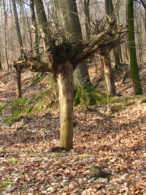 it is the first leg, but if I were a tourist I would prefer to end in Heidelberg. From Neckargemünd station (which is reached from Heidelberg by train in a few minutes) the path immediately leads uphill into the woods. After about 4 km there is a nice view on the river and back on Neckargemünd. This is followed by the longest uphill part of the leg. The highest point and highlight of the day is the Königsstuhl – Heidelberg's Hausberg – with its great view down on Heidelberg, the Neckar and the Rhine valley. Overseeing the flat Rhine valley and at its remote side its other limiting mountain range of the Palatinate as well as the hills of the Odenwald without even having to turn the head gives an impression of the Rhine valley's character as a rift valley as clear as it can be. Down to Heidelberg one can conveniently use the Schlossberg funicular or walk – as we did – the 1200 steps of the Himmelsleiter by that losing 300 m of elevation along a distance of 1000 m. The steps do not all match norm regulations for normal stairs such
  that this part can actually be experienced as the most arduous one of the day. Going down the road a few dozen more meters and we arrive at Heidelberg castle. It is a matter of attitude, if you dislike it as an overly touristic place or if you enjoy the view over Heidelberg's Old city and the equally historic as well as modern international atmosphere. Drifting and zigzagging through the Old city and with a stop in a cafe we reach Bismarckplatz where we catch a tram back to the main station.This is the last leg of the Neckarsteig trail. Officially it is the first leg, but if I were a tourist I would prefer to end in Heidelberg. From Neckargemünd station (which is reached from Heidelberg by train in a few minutes) the path immediately leads uphill into the woods. After about 4 km there is a nice view on the river and back
 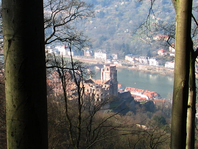 on Neckargemünd. This is followed by the longest uphill part of the leg. The highest point and highlight of the day is the Königsstuhl – Heidelberg's Hausberg – with its great view down on Heidelberg, the Neckar and the Rhine valley. Overseeing the flat Rhine valley and at its remote side its other limiting mountain range of the Palatinate as well as the hills of the Odenwald without even having to turn the head gives an impression of the Rhine valley's character as a rift valley as clear as it can be. Down to Heidelberg one can conveniently use the Schlossberg funicular or walk – as we did – the 1200 steps of the Himmelsleiter by that losing 300 m of elevation along a distance of 1000 m. The steps do not all adhere modern
 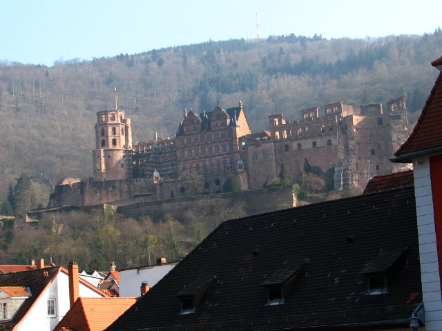 regulations for normal stairs such that this part can actually be experienced as the most arduous one of the day. Going down the road a few dozen more meters and we arrive at Heidelberg castle. It is a matter of attitude, if you dislike it as an overly touristic place or if you enjoy the view over Heidelberg's Old city and the equally historic as well as modern international atmosphere. Drifting and zigzagging through the Old city and with a stop in a cafe we reach Bismarckplatz where we catch a tram back to the main station.
Clear view: 4/5
Nature: 2/5
Culture: 5/5
From Esslingen to Bad Cannstatt
This route is also near the Neckar river, but  80 km to the south. The starting point Esslingen is a Town with a long history and an extended Old City. It is a good idea to zig-zag a bit through it, before entering the staircase of the City Walls to walk up to the Schönenberg with the Dicker Turm, where one can look back on the Town. On the following about two km through the more elevated parts of Esslingen we met a number of people doing their "Kehrwoch" duty on the street in front of their house, which is anecdotical to a level that it could nearly be called mythological. In autumn time as it was Kehrwoch is a heavy duty with all the leaves on the ground. After the last houses of Esslingen the path leads through forest and along
  vineyards almost always with good sight to the valley to the West, to which Stuttgart and its neighboring towns stretch (the city of Stuttgart has a population of just about 600,000, however the greater area is comparable to the one of Cologne, Frankfurt, and Munich). On the top of the moderate hill there is the "Katharinenlinde" (a lime tree) and an equally named restaurant with a look-out. Along the route of this track it is probably a good time to take the chance of a lunch (which we did). It is also a good place, because from here it's going downhill in all directions. From the look-out a monument in the distance is already visible which is the next intermediate destination: the Mausoleum of the House of Württemberg on the Rotenberg. The meters inbetween are once more all between vineyards. We saw a number of fires in the vineyards; with a bit
  fantasy in these days these could be imagined to be fires of the station insurgency :-) Towards their former regents the Swabians show more affinity. The area around the mausoleum was lively crowded, crowded enough that it pays to take an admittance fee. The interior has been taken well care of. Especially the tomb (downstairs) is impressive. It has nearly perfect acoustics. From the mausoleum the path goes downhill toward Stuttgart, often with the city's major soccer stadium straight ahead. The trip might be the best way to approach to Stuttgart, however, at the boundaries of the city there are a few unpleasant meters along a large street. You can now either go straight for the station of Bad Cannstatt or first to its Kurpark. There is a museum dedicated to Gottlieb Daimler, one of the inventors of the car who had his workshop there. The Kurpark is close to the Neckar river along which one can walk to the city center and from there to the station.
Clear view: 4/5
Nature: 3/5
Culture: 4/5
A Word on the Neckarsteig
In January 2012 the Neckarsteig was presented as an official hiking trail and was immediately certified to be of high quality. Running a homepage as I do one can imagine that I like the idea and am happy that this project has been realized. However, I was surprised in parts about the course of the trail. With my previously GPS files published on this page a reader might want to have from me an estimation about the differences between my path choice and the one of the Neckarsteig. And that's what I want to do with the following lines.
It is one thing to plan a tour privately. One has all freedom to follow a paradigm to maximize the scenic or cultural or culinary or whatever one likes experiences. Creating an official and certified trail is a different thing. Communities can forbid the trail to pass their grounds, they cannot stop people just walking somewhere. The certification process might yield other constraints. The most scenic part might only be accessible by a bad or dangerous path and therefore not end up in the final official trail. Therefore there are good reasons that an official trail is not considered as the best path choice by a considerable number of hikers. Of course there is not a single-best choice as different people have different preferences. The following path choice through the Neckartal is my personal synthesis between my other GPS files on this homepage and the official Neckarsteig, as I found that – compared to my previous choice – the Neckarsteig made some good deviations, while for other differences I can only think of political or formal reasons why the official route choice was made as it is.
First let me tell you good reasons to NOT deviate from but STAY ON THE OFFICIAL PATH: the official path is being taken care of continuously. If there forest operations make a part of the official path impassable, there will be a detour marked, which will not be the case for other ways nearby. It may even happen that a path is given up permanently and given back to nature's custody. After all some of my GPS segments are from 2008. Furthermore my own directions include some very scenic paths, but the path is more dangerous than the official one. I am careful enough to not walk somewhere where death lurks each moment, but in this aspect the official path surely has been estimated more rigidly to acquire the certification as high quality trail.
But now for the changes I suggest compared to the official trail even after I have dealt with the official course. First I suggest to walk not from Heidelberg to Bad Wimpfen, but the other way round. Bad Wimpfen really is a scenic village, but it is in a way more aspiring to have Heidelberg as a destination for a week or so. And I think it is more natural to follow the river instead of walking against it. One can then read Twain's book in the right order in the evenings. Switching the main direction of the trail has a consequence: I like to walk canyons uphill, as I think that first one has a better view and impression and second – canyons typically being the most dangerous parts – it is saver than going down. This means that I would modify the track below for someone who walks from Heidelberg to Bad Wimpfen.
The first small change is that the trail sets out through the center of Bad Wimpfen and does not pass it by. The same I have chosen for Gundelsheim: pass through instead of passing by. After having passed the Michaelsberg I have a small preference for staying at the height instead of going down again to the Neckar. At the Burg Hornberg the opposite is the case: different to the official trail I suggest to go down again to the Neckar. This is to later have the opportunity to pass the Tempelhaus, walk through Neckarelz and along the Elz creek into Mosbach. I am pretty sure about this change and cannot see a reason for walking to Mosbach above the hill. In Mosbach we come back to the official route. Above Diedesheim I suggest a detour for a few nevertheless steep meters for scenic reasons. Near Binau my track suggests a variant which comes close to the station of Binau. This is interesting for people who want to set out or end there. My variant reaches the Margarethenschlucht at its lower end and does not turn at the upper end, but leads on high above the Neckar, passing the Gickelfels. The view from there is the reason for this modification, however, the official route, which turns at the upper end and leads on below is also very nice. Both variants meet at the rails in Neckargerach. Shortly after that one has to pass the bridge over the Neckar. I have sticked with the big loop around the Mittelberg, but if one turns left instead of passing under the bridge (on the left river side) one follows the direct path to the Minneburg and saves some km, which probably cannot be counted to the highlights of the trail. In the forest behind the Minneburg at the upper end of the left-river-side-Minneburg there is the furcation for the biggest difference between the official route (walk left) and my preferred one (walk right). My variant leads soon down again to the river and reaches it right at a new bridge to Zwingenberg. Pass the bridge and turn left. Sorry for the few meters along the national road. Go to Burg Zwingenberg. Now you are at the lower end of the right-river-side-Wolfschlucht, the much more impressive and known one of the two. At the entry there is a sign giving an explicit warning that entering is dangerous. If you would turn around here, better walk left earlier at the furcation. This variant also leads over the Katzenbuckel -all of which is described above – and reaches Eberbach and with it the official trail from the hill-side. It might be worthwhile to consider to stay in Eberbach for two nights and walk on the official trail, but do this variant as a loop on the additional day. In Hirschhorn I suggest a different way down from the castle to the village, and that's pretty much all of the differences. Ifyou think you still can keep going some more days, then follow the Odenwald-Vogesen-Weg either northbound to Darmstadt or southbound via Karlsruhe and Wissembourg to the Vosges.