Hiking in Les Vosges du Nord
The Northern Vosges geologically are nothing but the southern part of the Palatinate Forest (see separate page). It is politics and history which has set the two apart. Even the language changes gradually. In the villages close to the border people typically speak French as well as German and when they are among themselves not rarely switch a number of times from one language to the other within one single sentence. Looking from Paris or Berlin this region may be as remote as a region can be. Yet in a sense and for the hiker it is the heart of Europe and all the castles there tell that historically in fact it was heavily fought for.
Tracks
| From Wissembourg to Niedersteinbach | GPX | 28 km | 12/11 |
| From Niedersteinbach to Baerenthal | GPX | 26 km | 9/9 |
| From Baerenthal to Ingwiller | GPX | 20 km | 7/8 |
| From Ingwiller to La Petite Pierre | GPX | 17 km | 6/4 |
| From La Petite Pierre to Saverne | GPX | 22 km | 8/9 |
| From Saverne to Dabo (La Hoube) | GPX | 17 km | 8/4 |
| From Dabo (la Hoube) to Oberhaslach | GPX | 23 km | 11/14 |
Descriptions
From Wissembourg to Niedersteinbach
As the Deutsche Weinstraße has its south  end in Schweigen or Wissembourg respectively, we now change to a trail known as Transvosgienne, which officially starts in Lauterbourg. While the Weinstraßen trail follows he Eastern edge of the Pfälzerwald, now our path leads into the mountain range and therefore consequently leads upward out of Wissembourg. We pass he Maison Forestière Scherhol and remains of some old military infrastructure. Climbach would offer the chance to have a lunch, but it is still too early. Climbach as well as Petit Wingen, which follows soon after are two Alsacien villages which are alike small as pittoresque as they are remote (in our experience as hikers). Out of Petit Wingen we follow a calm, green valley with a small creek in a wide curve until we reach a parking place which is much more lively again. It is located at the foot of the hill of the Hoehenbourg which is an extended ruin. Climbing both the hill and the ruin pays off with a wide view over les Vosges and the Pfälzerwald. Even Trifels is in sight. Much better of course is castle Fleckenstein, which lies closely below Hoehenbourg.
 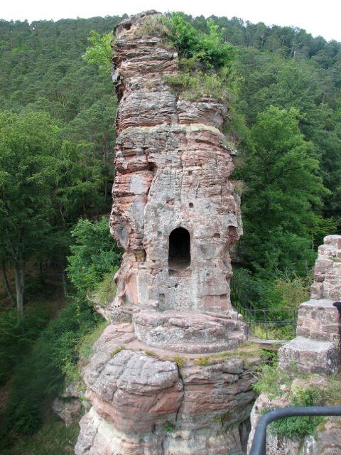 The path down there leads along an interesting line of rocks, which resembles a spot near Trifels. Compared to the rest of this and especially the two following days Fleckenstein is crowded. Economic activity there has gotten a kick start with money from the European Union which seems to be successful and to pay off. After our rest we are happy to realize that the track seems to descend entirely until our destination Niedersteinbach. However, that's not exactly true. Every meter of elevation we loose after Fleckenstein we are forced to regain right after when we have passed the edge of l'etang du Fleckenstein – not the easiest part of the day as it has been long already until that point. Yet whoever planned Transvosgienne knows why he sends the hikers this way. Already in the vicinity of Niedersteinbach the trail passes the Foerensbourg. It is by far not as large as Hoehenbourg and Fleckenstein, but it is very interesting to see how this castle makes use of the rock on which it is located. It is hard to guess from the ruins which are left, but probably the castle was half carvedinto the rock and half masoned on top of it. In Niedersteinbach we have our dinner in the Au Cheval Blanc – a restaurant which is known well also outside Niedersteinbach and even outside les Vosges.
Clear view: 4/5
Nature: 4/5
Culture: 4/5
From Niedersteinbach to Baerenthal
Niedersteinbach really is not a large village and 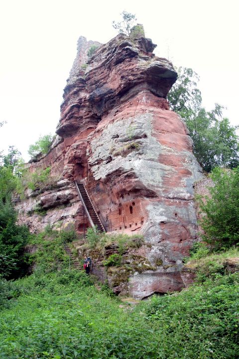 therefore we have quickly left it behind us and follow the valley of the Steinbach creek to Obersteinbach, which clearly has some more houses. Obersteinbach is a typical Alsacian village. It stretches along the main road and its sight is dominated by another ruin-on-rock above it. On our road out of Obersteinbach once in a while there is another house, such that it is not exactly possible to tell where the village ends. Finally we pass the Maison Forestière after which – as we note later – there is no more house, but the track leads into a Réserve biologique, hich is also a Naturreservat, as it stretches to both sides of the French-German border. There the forest is left to its own to grow. At an info point at the entrance it is explained that it is an experiment about which kind of forest is going to develop. For the next two hours we are inside this very quiet forest. It is nice, calm, and unspectacular, except for one sight, which was in place long before someone in Paris and Berlin decided to let these outer parts of both countries be reigned by the forest and nothing else: the ruins of Lutzelhard. There are castles in better shape, there are ruins which once were larger castles and there are castles with a better clear view, but by how this ruin-on-rock dominates its surrounding and how on this steep rock in addition a castle was built and how the dense vegetation has surrounded it, seemingly trying to
 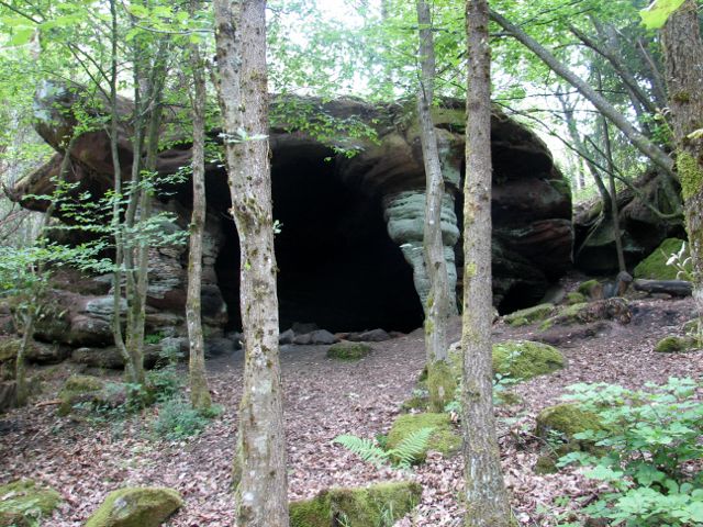 overwhelm it, but yet failing for the height of the ``construction'', it might be the most impressive of all the many ruins-on-rock which we pass in les Vosges. In the forest we pass from Alsace to Lorraine and the Welschkobertweier, a small lake. When having finally made the way through this forest the first thing outside is a strange village named Stürzelbronn-Hardt. It is strange because only a fraction of the houses appeared to be inhabitated, a significant number might be vacation houses, which makes the place a ghost town in other times. Very soon after having left the road which connects Hardt to the rest of the world and the path has started to lead upward, the landscape appears to be somewhat remote. Shortly below the top of the col, the vegetation soon will succeed in overgrowing the path, at least that's the impression one gets. The next intermediate destination is l'étang d'Erbsenthal, another quiet lake.
  The way there is along the hillside of a steep valley where at one point there is a rock cavern, which looks very much as if it were crafted purposefully, yet it is natural. The lake is at the ground of a valley on which opposite site the next incline waits for us. The effort pays off with the sight of the Erbsenfels which is clearly the largest and most impressive rock we have seen on this tour. As rain was approaching we decided to skip ruin Waldeck and directly head for l'étang d'Hanau where the rain actually caught us. The lake's shore was the first spot to be a bit more lively for hours of that day. Beyond the lake the trail first leads through flat terrain and one thinks that Baerenthal is only minutes away, but then the col du Dunkelthal requires to be passed and the last col is the one of the château de Ramstein which already offers a view over Baerenthal.
Clear view: 3/5
Nature: 4/5
Culture: 4/5
From Baerenthal to Ingwiller
This morning Baerenthal leaves no time for a  comfortable warm-up. The first two kilometers lead 200 meters upward. After about two more km we pass back to Alsace at the col du Zollhäusel. From there the wide and comfortable path, which does not require much attention for safe walking and therefore leaves freedom for some chat, something which is rather an exception than the rule in this region, leads to Reipertswiller. Reipertswiller appears to have been built such that architects can shoot photos for their brochures. Nearly all houses are new and/or kept in a tremendously good shape, yet one might miss the mellow-ambient charme of other Alsacian villages. Already before one sees the first houses of Reipertswiller, one can see Lichtenberg on the hill on the opposite side of the valley. Lichtenberg actually does not lie so high over Reipertswiller as it appears first, but the last few meters are very steep and covered by ants who battled for pieces of vegetation three times as large as each of them. Above Lichtenberg there is the castle and fortress Lichtenberg,
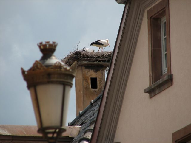 which was in military usage for more than 600 years. The following about 200 ''don't know what to do with it'' years have been followed by now already 20 years of costly reconstruction for touristy and communication purposes. After having found out the right exit from Lichtenberg towards Ingwiller, we walked through Champagne and further down the road until the signs pointed away from it up onto a narrow path into the densest forest I can remember to ever have seen. Next to it is located the ruins of the Tierkirchlein, a church where peasants brought their sick pets to pray for cure. We then followed the signs along the direct way to Ingwiller which described an extensively wide arc. After five kilometers in the forest, Ingwiller comes into sight. Ingwiller is typically Alsace: half-timbered houses, red stone churches, flowers throughout the village and storks, and everything that can be is a bit worn-out.
Clear view: 2/5
Nature: 3/5
Culture: 4/5
From Ingwiller to La Petite Pierre
The track sets out at Ingwiller station. We  are here off the main route of the GR 53 and the way is entirely unspectacular and relaxing. It leads almost all the time through a forest. The forest and the small maximum altitude of 370 m make that it offers nearly no clear view. Although the road connecting Ingwiller and Petite Pierre we had the impression that the forest is left mainly to itself. There are no stacks of wood and no benches. For a few seconds I saw a bird which might have been a capercaillie,
  however, as far as I know the reintroduction of this bird to the Vosges has just begun. Along the route there is no cafe or restaurant, however, there is no need for one on such a short leg anyway. At the end the Imsthal requires the hiker to first descend and then finally to ascend to La Petite, passing at fist the Maison des Paiens. Arriving early is not only easily possible, but also a good idea, as there is a lot to see in La Petite Pierre although it is a small town.
Clear view: 1/5
Nature: 3/5
Culture: 3/5
From La Petite Pierre to Saverne
We leave Petite Pierre southbound to a hill  plateau which falls off to all sides except the one of Petite Pierre. Consequentlyat the southend – at the Rabenfels – the path leads steeply downward. to the Imsthal and Kohlthal. There are only a few flat meters past a scenic small lake and we go uphill the Weyerkopf. Its peak is not a peak, but rather flat and in its vicinity the trail leads through a forest with a distinct and friendly appearance. The descend to the Rehbach is less steep than the ascend. The people there
 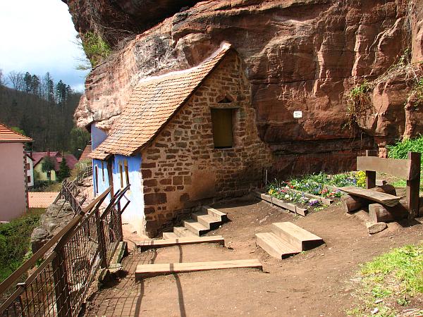 have ponded the Rehbach to numerous fish lagoons. There where the Rehbach valley meets the valley of the Zinsel.the village of Graufthal is situated with its famous rock houses. The walk through the valley of the Zinsel is quiet and flat. Before we have to go upward again a restaurant in Oberhof offers a chance for a coffee. With the top we reach a more or less flat plateau which reaches we will leave only to walk down to Saverne. After about two km on the plateau at the moment (2012) one reaches the construction site for he second construction section of LGV Est
 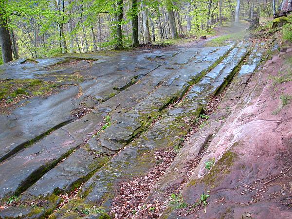 and can see the marked Western entrance of the Tunnel de Saverne (from the east the machines have already begun to make their way through the hill). Soon there will be a bridge crossing the rail and right next to it there is a bridge over the Autoroute de l'Est. The third arterial to cross is the Rue Nationale and approximately from there on we are on the ancient Roman passage over the Vosges. Beneath the Rocher du saut du Prince Charles the Romans have left
  impressive traces in the sense of the word. Over the centuries their wagons have carved about 10 cm deep into the rock; four grooves for two lanes on which there must have driven cars all having their wheels at the same distance. There where the necessary height was almost gained they supplied a station. From the rock there is a tolerable sight on Saverne, given it does not rain too much. The remaining way down to Saverne is a piece of cake.
Clear view: 2/5
Nature: 3/5
Culture: 4/5
From Saverne to Dabo (La Hoube)
We leave Saverne - not before having explored  its Château des Rohan and its city center – by first crossing the channeled and barrage-equipped Zorn river and follow it for some time by that passing a table informing about no less than nine different trail symbols and the routes they mark. Already within the town the path leads upward. To reach the first destination for today we have to do 250 m altitude. As a reward Château Haut-Barr offers to be explored, holds the possibility for a coffee, and allows a wide view into the Rhine valley which has its broadest part in that region. On the other side the higher points of the castle allow to see the Zorn meandering their way through the Vosges. So far the TGV has to follow the path the Zorn prescribes. A telegraph house which used to be part of the connection between Paris
and Strasbourg is Haut-Barr's not nearly as old, but still outdated, neighbor. The next 3 km are very easy going before a climb of another 100 m leads to the Tour du Brotsch, a tower which is high enough that the surrounding trees have not made it to occlude the view. The Rocher de Dabo can already b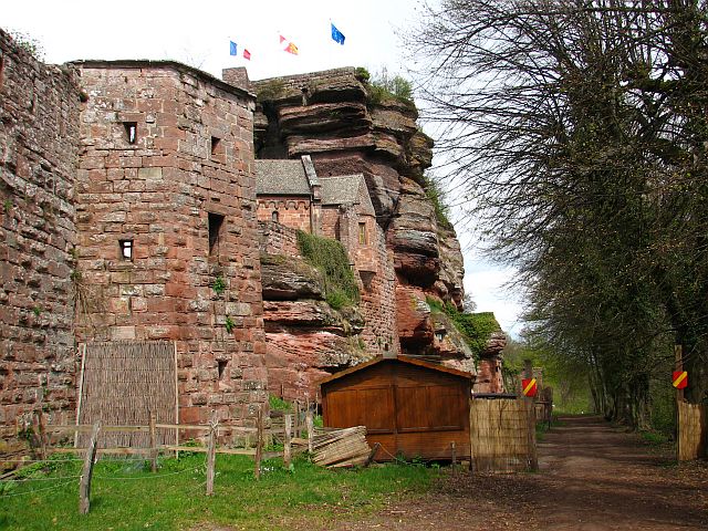 e seen from here. The Brotschberg plateau which extends southbound holds some very bizarre rock formations. Having descended from the Brotschberg there is the Maison Forestière du Schaeferplatz marks about half the distance (but much more regarding elevation meters) of the leg and the Schaeferplatz itself offers a good place for to rest. From now on with the exception of the last two km the path leads gently uphill and the feet go easily through the forest. Right when the first house comes into view again we pass the border between Alsace and Lorraine or Bas-Rhin and Moselle. And shortly thereafter a small creek has carved a valley and thus created the last obstacle between us and Dabo-La Hoube. The valley is equally steep on both sides, but on the other side there is our destination for today. Of course one could also proceed to stay in Dabo, but the La Hoube offers a great view of the Rocher. This is valued by a number of people as many newly built large houses show. Accessing Dabo like this may give the
 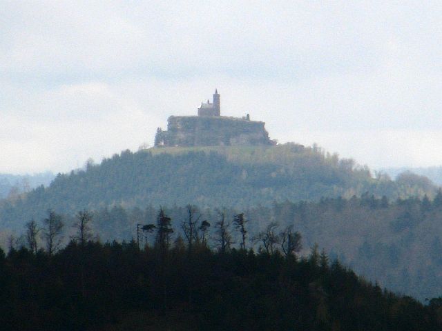 impression of Dabo being remote. It is not so much so as neighboring towns are not so far away. However, continuing in this direction (south-west) a large extremely sparse populated region extends, which in that region is the natural gap between villages in which still German is spoken and such in which it is not . We could follow a chat at our neighboring table in the restaurant and concluded after some time that it must be German and not French which people spoke, although we could not understand much, as it was a very special kind of German (Twain would have been willing to pay much to take it home and put it into his collection of rarities). Linguists definitely should go and make these villages a playing field of theirs before these variants of German get lost.
Clear view: 3/5
Nature: 4/5
Culture: 3/5
From Dabo to Oberhaslach
This is still the Northern Vosges according to 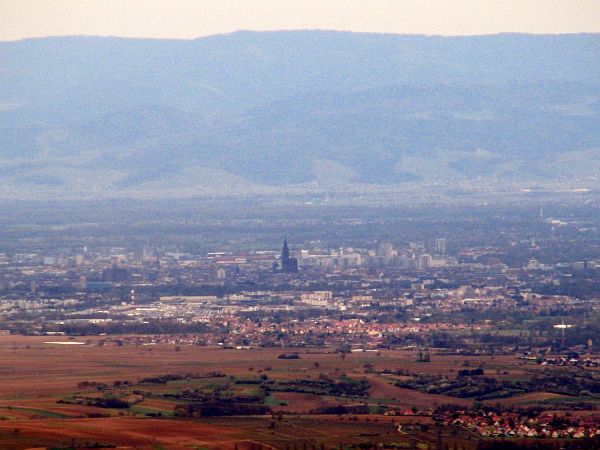 the official definition, but the hills are higher today than usually in the North. For us it was a rainy day and so we skipped Dabo and the Rocher itself and left it for a later visit. Probably the Rocher anyway is impressive to watch from far away and quite ordinary when you stand on it? Until the Col de la Schleif (a saddle with some grill and rest infrastructure which might be quite busy on days with a different weather) it is a comfortable walk. Then the path narrows and leads down to a few houses and a small
 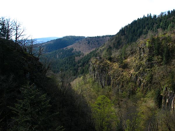 creek. An equally small bridge leads to the other side. Some time later we pass the edge of Wangenbourg a town which is named after the castle which towers above it. Now begins an about 4 km long way up to the Schneeberg along which there are some nice sights of Strasbourg. The Schneeberg has 961 m and thus is about twice as high than any hill of the Vosges north of it. It is not only today's peak, but also half-way. The first about four km downward are another example that it can be as arduous to walk downward as uphill. Then we arrive at the Ruines du Nideck, an old castle
 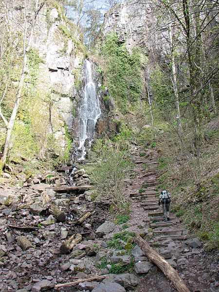 which has attracted hikers for more than a century now as it is the playground of the ballade of the “Giants' Toy” (a kind of early Toy Story, but in this case with humans in the role of the small ones). The ruin is not accessible. Soon beneath the ruines the Cascade du Nideck appears to have been made for an illustrated book of the Alsace. The rest of the day is easy going. We follow the valley down which becomes flatter and wider. Finally we arrive in Oberhaslach, which at this time around Easter honors its name (it could be translated as “High Bunny Waters”, which is probably not exactly true) and is over and over decorated with Easter Bunnies emphasizing it belonging to the Alsace which shares the German tradition that Easter Eggs are said to be brought by bunnies and not by Easter Bells as is the tradition everywhere else in France.
Clear view: 4/5
Nature: 4/5
Culture: 3/5